 Law enforcement now routinely uses cell tower location data in its investigations. This technology can identify the general location of a cell phone, sometimes to within a few feet! Until recently, this capability has been limited to the law enforcement community. GCIS is proud to be one of the few vetted private providers in Texas of the ZetX, Inc., Trax Software - a Cell Tower Data Mapping service, as well as their Lynx Telephone Toll Records analytical service. I recently attended the same formal training program that ZetX offers to law enforcement agencies nationwide.
Using Trax, we can take the Call Detail Records (CDR) and/or Google Location Data to plot the appromimate location of a cell phone. This information can be used in the following circumstances (just to name a few):
- Alibi Defenses
- DRAM Shop Cases
- Stalking Cases
- Personal Injury cases involving commercial vehicles
We can also plot the CDRs for multiple users to determine if they were in the same location during the same timeframe. Great for proving or disproving conspiracies!
Using Lynx, we can analyze massive amounts of telephone toll records and determine patterns of calls, who called whom, was a specific number ever called, common calls (comparing toll records of multiple users).
How it works:
The client obtains the CDRs from either law enforcement (if they obtained them) or directly from the telephone provider with a court order. GCIS will assist the client in obtaining these records by providing the proper technical language for your court order that is tailored specifically for each cell phone provider.
Upon receipt of the CDRs, GCIS will manually review them to ensure all the requested records were received in the proper format;
GCIS will process the CDRs using Trax and Lynx;
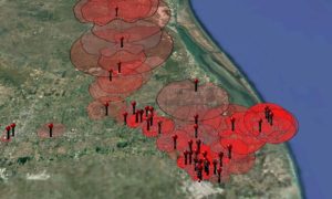
GCIS will produce an animated Google Earth map showing the location details as it pertains to your matter. The video below shows a time-lapse of activities plotted using Google Location data.
GCIS can plot this information into an interactive Google Earth file. The image below was generated from AT&T CDRs. Each red pin represents a cell tower. In Google Earth Pro, you can click on the tower pin and see all the calls, SMS, and/or data connections (depending on the carrier) generated through that tower.
GCIS will also analyze toll records as requested by the client.